Pseudo-medieval city maps
Roger of Roles, Rules and Rolls has reminded me to share some cities suitable for medievalish gaming.
See, I love Vornheim but I can never get comfortable generating cities procedurally on the fly the way Zak does because I feel like I need to have a real overview of the whole city in order to be able to run anything in it, because I want to know how far the players will have to run and around how many corners to reach the gate or the sanctuary of the temple when the angry mob comes after them.
And although Merv, Constantinople and Ankh-Morpork are all steaming cities of millions, I also like my in-game cities to be recognizably finite because then you don’t get the condition of anonymity and easy invisibility that adventurers tend to take for granted.
And I love drawing maps but I hardly ever actually do it because (a) time, (b) my maps don’t have that all-important element of the unexpected and irrational – they are designed for my current purpose, while actual places are always designed for a million conflicting purposes and so that’s why people routinely do stuff nobody would ever do like putting the prison and mental hospital next to the armoury.
So instead I use real places. Every time I travel I bring back a map. And there’s a surprising number of immediately usable real places right on Google Maps, which still have the outlines of “medieval” or “early modern” cities. So here’s a few. Be warned, the links below are mostly to HUGE images.
Let’s start with the most obvious candidate:

Venice was a bustling metropolis in its 15th century heyday, big and tangly enough to hide legendary assassins, secret police forces, multinational trading houses, a fearsome navy and a shadowy ruling cabal. And it still has a pretty similar street plan today – good enough for gaming needs, anyhow. Need to know the main sights? Go check out some tourism site, but basically the seat of government and sea trade tax office is right on the main wharf on the south side, by the mouth of the grand canal, and the navy yards are on the east end, and the bit that looks industrial on the west end was added in the 19th century, so lop it off if you don’t like that in your burlap medieval mudhellscape. Google map. Note that square Isola San Michele is the necropolis and that the church on the end of Dorsoduro, Santa Maria Della Salute (south side of the southern entrance of the grand canal) is an architectural charm to ward off the plague, which was still a recurring problem in the 18th century. If you can’t make RPG hay with that I don’t even.
")
Brielle in south Holland changed from the 16th century to the 17th and then gave up.


It still nestles in its cozy girdle of cannon forts waiting for the French, while next-door Rotterdam (which rather dominates this google map) metastasized out of its enceinte, got bombed to rubble, and re-emerged as a thoroughly 20th century industrial hub. The big white building’s the church (more obvious on this bird’s eye view), the rest was at one point almshouses, linen-processing yards, boatbuilding, stabling, and orchard gardens for the richer folks against the threat of siege. Note that it has exactly one main street where all the reputable taverns are located (that’s Hogsmeade right there), and before cars came along you could close the gatehouses on the moat at night, like at (delicious Victorian confection) Carcassonne, which I include even though it should already be in your library:

I’ll forgive you this time for not knowing about the fortified island at Concarneau [Google Map] [useful tourist map], a sort of Carcassonne-on-the-sea but less footled about:

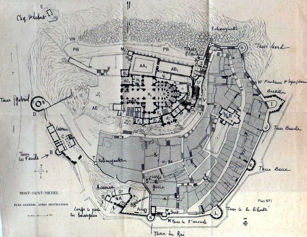
but you should really already know about Mont St. Michel

and be ready for when the players decide to knock over that dominating abbey.
Although the “medieval” towns of Tuscany are as mucked about by Mussolini as Carcassonne was by Viollet le Duc, as far as gaming goes that really just makes them better. Thus stereotypically hilltop Siena –

(Florence’s competitor, arrested after the 15th century by the plague, for our much later benefit) in 2 maps that are confusingly shown rotated one from the other but together get the idea across, gives you enough courtyards and palaces and back alleys for all your flashing blades skullduggery, plus the ludicrously dangerous horse race around the central “square,” Il Palio, beloved of James Bond location scouts and Travel Channel specials.
Smaller but no less reconstructed San Gimignano has a baffling profusion of towers suitable for spying on the population, hurling heretics off, storing grain or calling the multicretic faithful to prayer in an appalling religious cacophony 16 times a day.

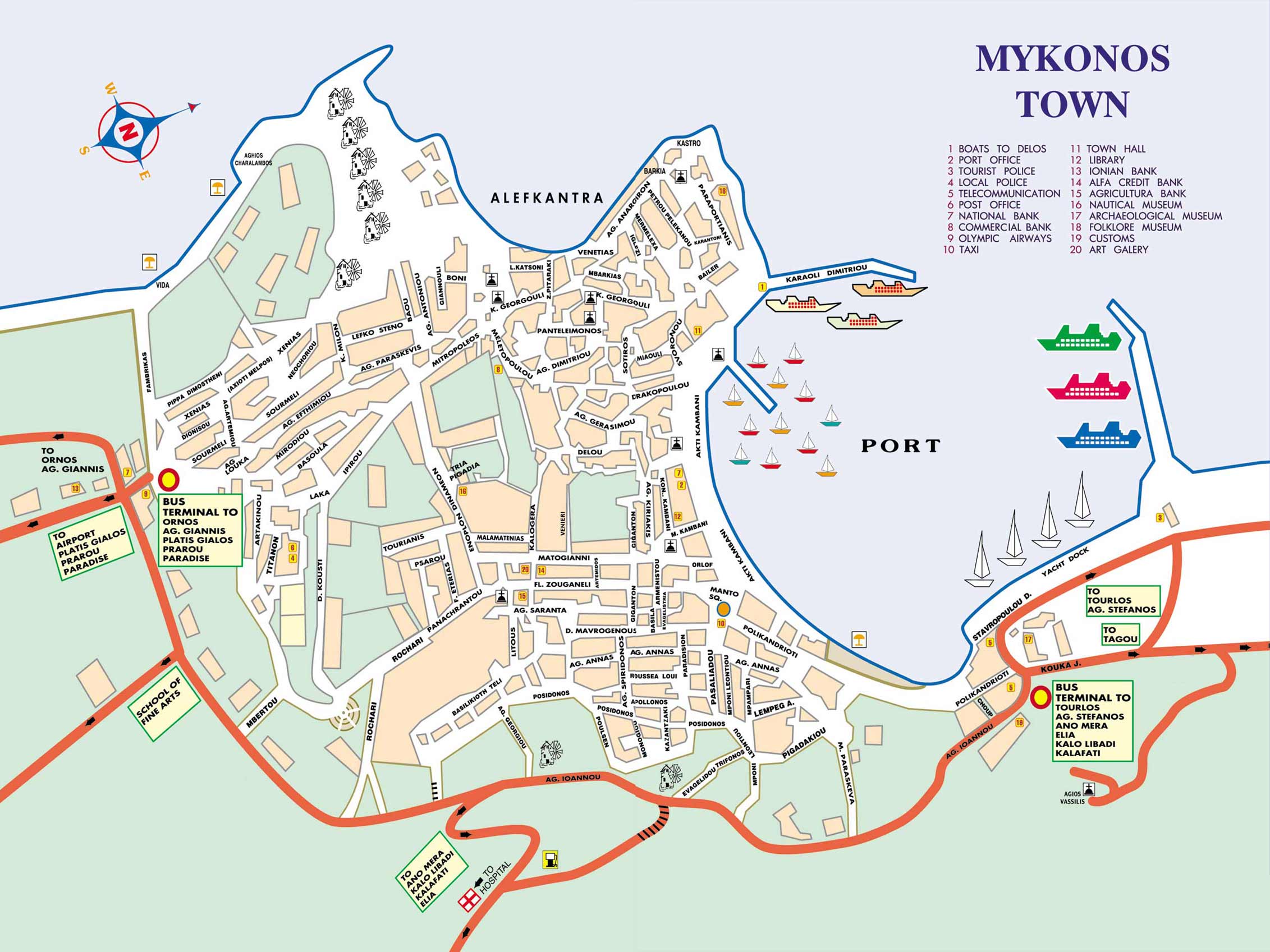
This map doesn’t show you the towers, alas, but oddly google maps steps up with an oblique bird’s eye, with captions. The size of San Gim is a useful reminder that these tiny little villages really were important urban centers 400 years ago. Wee Siena supposedly (unless Mussolini made it up which would be just like him) had/has 17 semi-autonomous districts that competed with each other in business, crime, church decoration and lunatic horse-racing. Which should give you a sense for what “locally famous” might mean. It’s also really easy to get lost in these small spaces: trust me, when everything’s whitewashed, even little Mykonos town can turn you around and around for hours.
Amsterdam was also a pretty small (but globally important) town up to about 1900 and, usefully for us, after that it expanded outward rather than effacing its old street plan in the center, so many of the buildings in the center date from the 1600s.
")
In 1649 (pictured in the map above) it was in the middle of its golden age: it was Europe’s biggest center for shipbuilding, a major hub for banking, international finance, the gold, silver and diamond trades, and (largely, maybe) controlled Europe’s access to the 4 noble spices, needed for holding the plague at bay and for entertaining in high society. It was also (perhaps) the most tolerant, multi-culti melting pot in Europe, home to deposed nobles and Jews from Spain and Portugal, middle-European economic migrants and refugees from the 30 years war, and a whole mess of troublesome Protestants and other heretics. This fascinating 5 minute video gives you a sense of the slow fits and starts with which it expanded, but to really get the size of the Jewel of the North Sea, I’ll tell you that it’s a 10 minute walk down the long 16th century axis from the harbour mouth to the south end of the Singel (enclosing canal/inner edge of those multiple rings of canals) and that’s adjusting for traffic and walking through the red light district. Note both in the map above and the last link, south is confusingly more or less at the top of the map.
Heading east to my favoured territory alas the Russians did a pretty good job of effacing backward and anti-modern Turkestan and replacing it with post-Soviet and anti-modern Central Asia.

There are hollowed-out museum cities (Khiva here has a weirdly lacey, patchwork quality after the monuments were “cleaned up” by having the houses around them removed) but you have to use your imagination and there’s certainly no obvious easily-stealable urban fabric. Following that last map link though you can see the extent of the old walled city (ie the elite expensive bit) pretty clearly. Mythopoeic Ramblings has already posted this lovely necropolis, which is useful too.
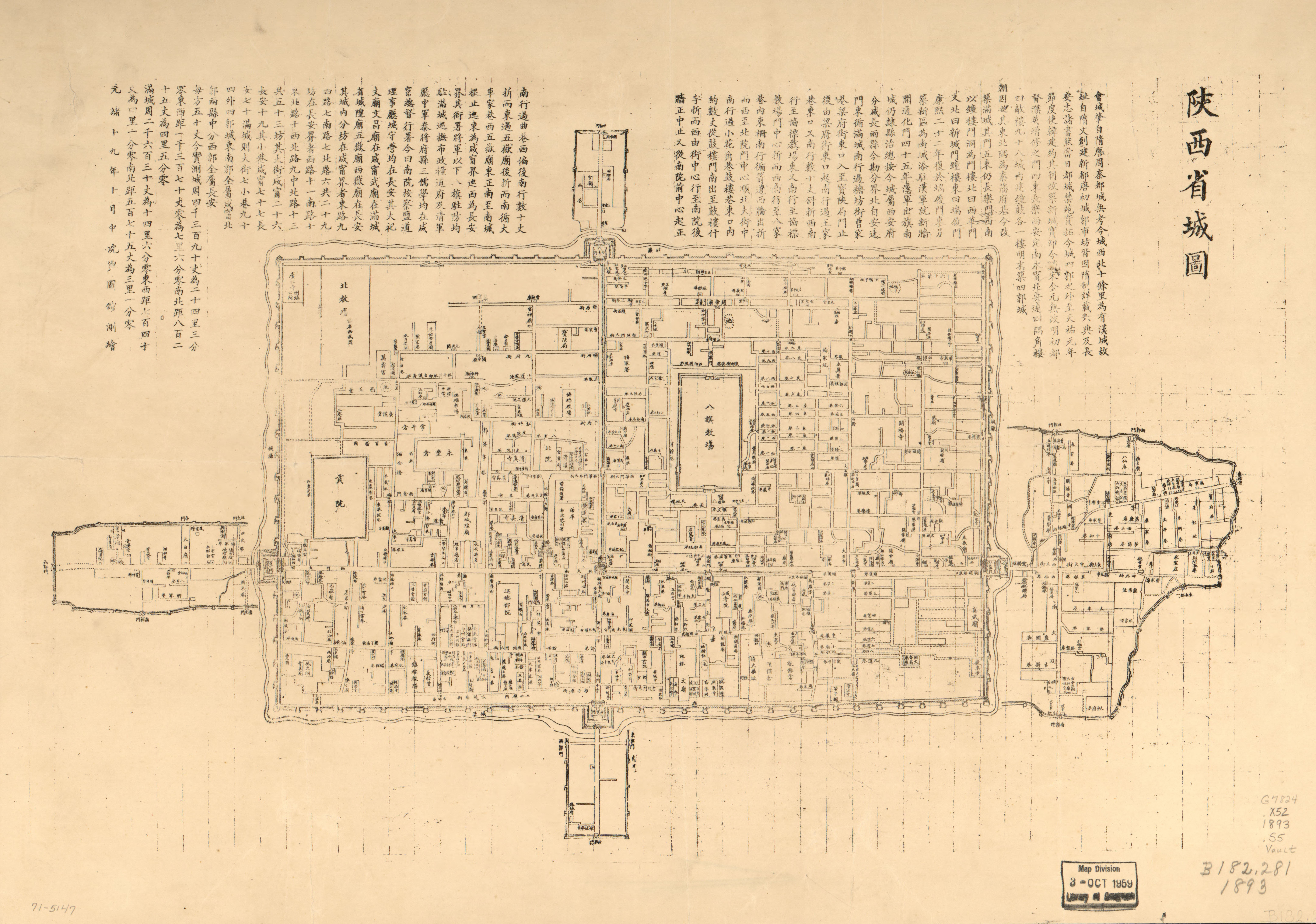
Supposedly the Islamic City is defined by a knotty tangle of semi-private courtyards and alleyways and underporches that makes it hard to map in a top-down way (although mostly when people say “the Islamic City” they mean “Fes“), so Zak’s methods seem tailor-made for this kind of confusion. But Chinese-influenced cities tend to have a brutal (but often subverted) regularity to them. Thus the capital of China’s legendarily cruel and paranoid First Emperor, Chang-an (shown in that link in its 19th century refiguring but there you are), and northern Thai (Lanna) stronghold, Chiangmai:

[google map to compare] which is about as square as Thailand’s “first capital,” Sukhothai:

give you a sense of life and love in the time of autocratic government.
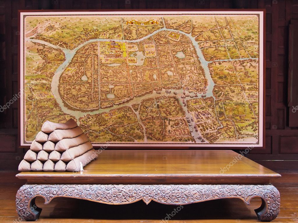
Less geometric and considerably more fun, Ayutthaya in the 17 and 18th centuries had quarters for visiting Arab, Chinese and European tribute-traders, intrigue galore, a Greek con-man grand vizier, massive flammable palaces for state cremations, and Samurai bodyguards for the king. It’s also a demonstration case for the problems of generating maps from textual sources. Amusingly/irritatingly, the most useful map is not this complete image (nor google’s tidy map) but this dodgy partial pic out of a book:

Now it’s a “historic park” with the emphasis on “park” – crumbling temples separated by golf lawn grass, its solid stone Manhattan skyline still gives you some sense of the weirdness of arriving in a place with different gods:

but if you were to sail there in the 17th century in your trading ship, after navigating a hundred miles of jungle river you might start to lose faith in the supremacy of your cannons. You might be unnerved to be greeted by inspectors dressed as monkey demons, and bewildered to arrive finally in a City of Giants or Animate Statues, chillin’ right now, but ready to take offense at your barbarous ways.


Leave a reply to Crochets Cancel reply
 Scrap Princess
- BEAST PEOPLE NAMES FOR BEAST PEOPLE
- Six Secret Books
- NooFutura available for purchase
- Leucrotta
- Weapon Breakage In Darksun
- Kickstarter Cognition Snare, 8th part of the Hexahedron of the Monks of Flame
- 6th Part Of Kick Starter Cognition Snare, The Hexahedron of the Flame Monks
- Kickstarter Cognition Snare: Hexahedron of the Monks of Flame : The Fouth Part
- Kickstarter Cognition Snare: Hexahedron of the Monks of Flame : The Second Part
- Demon Bone Sarcophagus Kickstarter Is Awrithe!
Reading Appendix N
- Two of my favorite practical mechanics in Delta Green
- A wild hair
- Longest campaigns I’ve played from 2008-2022, and other data neepery
- Going full-depth: collecting complete game lines
- My 2024 RPG collecting goal: All of Ars Magica 5th Edition
- DCC dice, inking, and pencils
- Sailing out of the painting doldrums with Blood Bowl
- New year, new look
- My Black Furnace #dungeon23 project is done!
- Godsbarrow apocalypse narrowly averted
Roles, rules and rolls
- Night's Dark Terror 15: Journey's End in Rifllian
- Night's Dark Terror 14: Funny Things Happen on the Way to the Horse Market
- New Dungeon Just Dropped! (Ancient School)
- Night's Dark Terror 13: Xitaqa 4, Curse You Golthar!
- Night's Dark Terror 12: Xitaqa 3, Up the Tower
- Night's Dark Terror 11: Xitaqa 2, Tower Base
- Night's Dark Terror 10: Xitaqa 1, Round the Houses
- Night's Dark Terror 9: Following the Clues
- Night's Dark Terror 8: Raid on the Goblin Fort
- Night's Dark Terror 7: Hexcrawling South of the River
Akratic
- Swords and Wizardry Kickstarter: 3 days left
- It’s Tolkien Reading Day
- Darkmaster plans for 2024
- James M. Ward, RIP
- OSRIC Player's Guide
- Against the Witch-King: Chapter 1
- Against the Court of Urdor Campaign – Part 2
- My RPG Foci: Fantasy and Eldritch Horror
- Will Gygax’s Castle Greyhawk finally be published?
- Against the Court of Urdor Campaign – Part 1
Lich house
- LOTFP Review: The Curious Conundrum of the Conflagrated Condottiero
- Catching Up with the Pillories (York 1630 Campaign)
- ACKS 2 Kickstarter - Last 24 Hours
- LOTFP Review: Winnie the Shit
- LOTFP Review: Galileo 2: Judgment Day
- LOTFP Review: Black Chamber
- Game Reports - ACKS and LOTFP
- The Strigoi - Vampire Alternative for LOTFP
- LOTFP Review: A Gift for All Norway
- Game Reports - York 1630 and ACKS Greyhawk

Great pics and maps! National Geographic had a map of ancient Alexandria just a few months ago, which would be a nice addition, as well.
Outstanding.
May I also nominate Peñiscola in Spain.
http://velvetescape.com/2010/08/the-stunning-fortified-town-of-peniscola/
Here’s an excellent resource for old maps, especially the overhead view sort: http://historic-cities.huji.ac.il/historic_cities.html
Some of my favourites:
Buda and Pest surrounded by the ruins of the old city:

Mukachevo, a.k.a. the Keep on the Borderlands Mk. II:

Bitlis, overlooked by a sorcerer’s tower:

Cairo with dreamlike landscape to the east:

There is so much to use here I am a little lost even
Am I late to suggest to check out Cuenca’s Casas Colgadas (Spain)? http://stc.obolog.net/multimedia/fotos/51000/50958/50958-44559.jpg